'%3e%3ctitle%3elodging%3c/title%3e%3cpath d='M3.2 5.6c-1.76 0-3.2 1.44-3.2 3.2s1.44 3.2 3.2 3.2 3.2-1.44 3.2-3.2c0-1.76-1.44-3.2-3.2-3.2zM8 8.8c0 2.656-2.144 4.8-4.8 4.8h-2.4c-0.416 0-0.8 0-0.8 0.8 0 0.224 0 0.992 0 1.6 0 0.8 0.608 0.8 0.8 0.8h26.4v-3.2c0-1.6 0-4.8-8-4.8h-11.2zM1.6 18.4c-0.8 0-1.6 0.8-1.6 1.6 0 1.568 0 3.424 0 4.8 0 0.8 0.8 1.6 1.6 1.6s1.6-0.8 1.6-1.6v-3.2h20.8v3.2c0 0.8 0.8 1.6 1.6 1.6s1.6-0.8 1.6-1.6v-4.8c0-0.8-0.8-1.6-1.6-1.6h-24z'/%3e%3c/svg%3e)
Holiday apartments "Gerber 4 Residence" A15 and A106
Bulgarije (officieel: Republika Bulgaria), is een republiek in Zuidoost- Europa, gelegen op het Balkanschiereiland. De Balkan is een berggebied dat zich ten zuiden van de rivier de Donau uitstrekt.
De oppervlakte van Bulgarije is 110.994 km2, en dat is ca. 2,7 keer zo groot als Nederland. In het noorden grenst Bulgarije aan Roemenië (608 km) en de grens wordt daar over een afstand van ca. 425 kilometer gevormd door de Donau. In het westen grenst Bulgarije aan Macedonië (148 km) en Servië (318 km). De grens met Griekenland (494 km) in het zuiden wordt gevormd door de dalen van het Rodopi-gebergte. In het zuidoosten grenst Bulgarije aan Turkije (240 km) en in het oosten aan de Zwarte Zee (Cerno More). De grootste afstand van noord naar zuid is 330 km en van oost naar west 520 km.
De oostelijke kuststrook is het laagste deel van het land. Gemiddeld ligt Bulgarije ca. 470 meter boven de zeespiegel. Geografisch is Bulgarije in te delen in drie gebieden en de centrale bergketen speelt daarin een grote rol. Het Balkan-gebergte (Stara Planina) deelt het land namelijk van het westen naar het oosten doormidden en is verdeeld in Hoog-Balkan, West-Balkan en Oost- Balkan. In de Hoog-Balkan ligt een van de hoogste bergen van Bulgarije, de Botev (2376 meter). De gemiddelde hoogte bedraagt van dit gebergte is ca. 700 meter.
Het Donau-laagland of Donau-Bulgarije ligt ten noorden van het Balkan- gebergte en is een naar het noorden afhellend, zeer vruchtbaar lössplateau, dat tegen de Donau met een steile
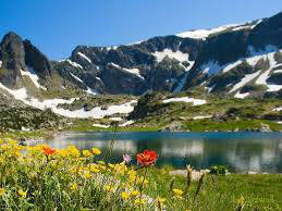
oever afbreekt. In het noordoosten ligt het heuvelachtige woudengebied van Deli Orman, dat de overgang vormt naar de Dobroedsja. Ten zuiden van het Balkan-gebergte ligt de Thracische Laagvlakte en daarna komen drie belangrijke massieven: het Rila-gebergte,
het Pirin-gebergte en het Rodopi-massief, dat tot ver in Griekenland doorloopt. De hoogste top van Bulgarije ligt in het Rila-gebergte en is de Musala (2925 meter).
Bulgarije telt honderden rivieren en enkele daarvan spelen een grote rol bij de afwatering
en bevloeiing van het Donau-laagland en de Thracische Laagvlakte, met name de Donau (Bulgaars: Dunav), de Iskâr en de Jantra. Andere belangrijke rivieren zijn de Tundža, de Marica, de Struma en de Mesta. Bulgarije kent geen natuurlijke grote meren, wel
enkele grote stuwmeren.

Bulgaria (officially: Republika Bulgaria), is a republic in southeastern Europe, situated on the Balkan Peninsula. The Balkans is a mountain range that extends south of the Danube river.
The area of Bulgaria is 110 994 km2, which is approximately 2.7 times larger than the Netherlands. To the north Bulgaria borders Romania (608 km) and the boundary is about a distance of about 425 kilometers formed by the Danube.
In the west Bulgaria borders Macedonia (148 km) and Serbia (318 km). The border with Greece (494 km) to the south is formed by the valleys of the Rodopi Mountains. In the southeast bordering Bulgaria to Turkey (240 km) and to the east on the Black Sea (Cerno
More). The greatest distance from north to south is 330 km and 520 km from east to west.
The eastern coastal belt is the lowest part of the country. Average Bulgaria
is around 470 meters above sea level. Geographically share in Bulgaria in three areas and the central mountain range plays a major role. The Balkan Mountains (Stara Planina) it shares ie from west to east in half and is divided into Upper Balkans, Western
Balkans and Eastern Balkans. In the Upper Balkan is one of the highest mountains in Bulgaria, Botev (2376 m). The average height of this mountain range is approximately 700 meters.
The Danube Lowland or Danube-Bulgaria is located north of the Balkan Mountains and is a north sloping, very fertile Loess Plateau, which breaks down to the Danube with a steep bank. In the northeast lies the hilly forest areas of Deli Orman,
forming the transition to the Dobroedsja. To the south of the Balkan Mountains, the Thracian Plain and then come three important massifs: the Rila, Pirin and Rodopi Mountains massif, which extends far into Greece. The highest peak in Bulgaria is located in
the Rila Mountains and the Musala (2925 meters).
Bulgaria has hundreds of rivers and some of them play a major role in the drainage and irrigation of the Danube lowland and
the Thracian Plain, especially the Danube (Bulgarian: Dunav), the Iskar and the Jantra. Other important rivers are the Tundža, the Marica, the Struma and Mesta. Bulgaria has no natural large lakes, but several large reservoirs.
